![]()
Take a look around. For in this place you will find maps and sketches of lands visited and explorered by many adventurers. You never know, that dusty, torn old map over there may show the path to that kings treasure you were searching for....then again, it may show the the route to your demise!.
Below you will find all manner of maps detailing the various locations of the Realms.
|
|
|
|
|
|
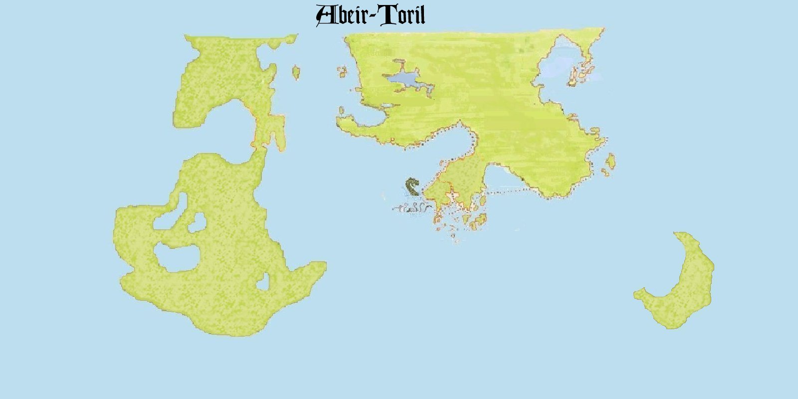
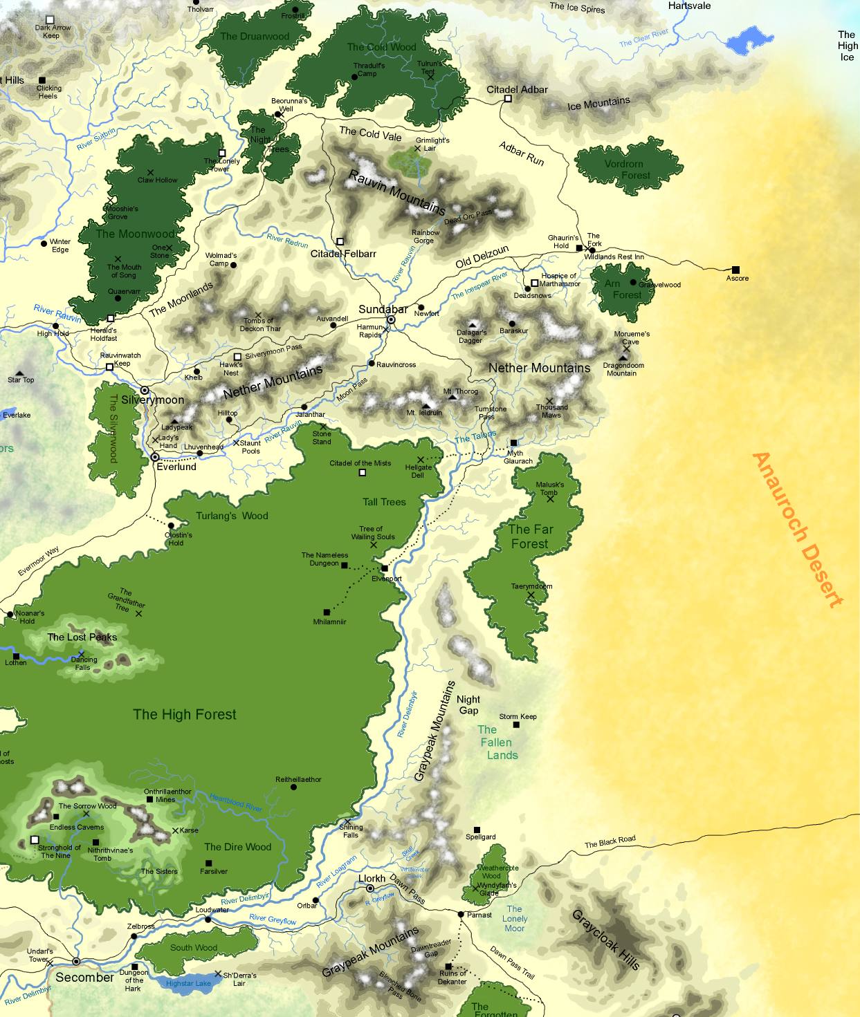
| Continents Map of Abeir-Toril | The North (also available for Campaign Mapper) |
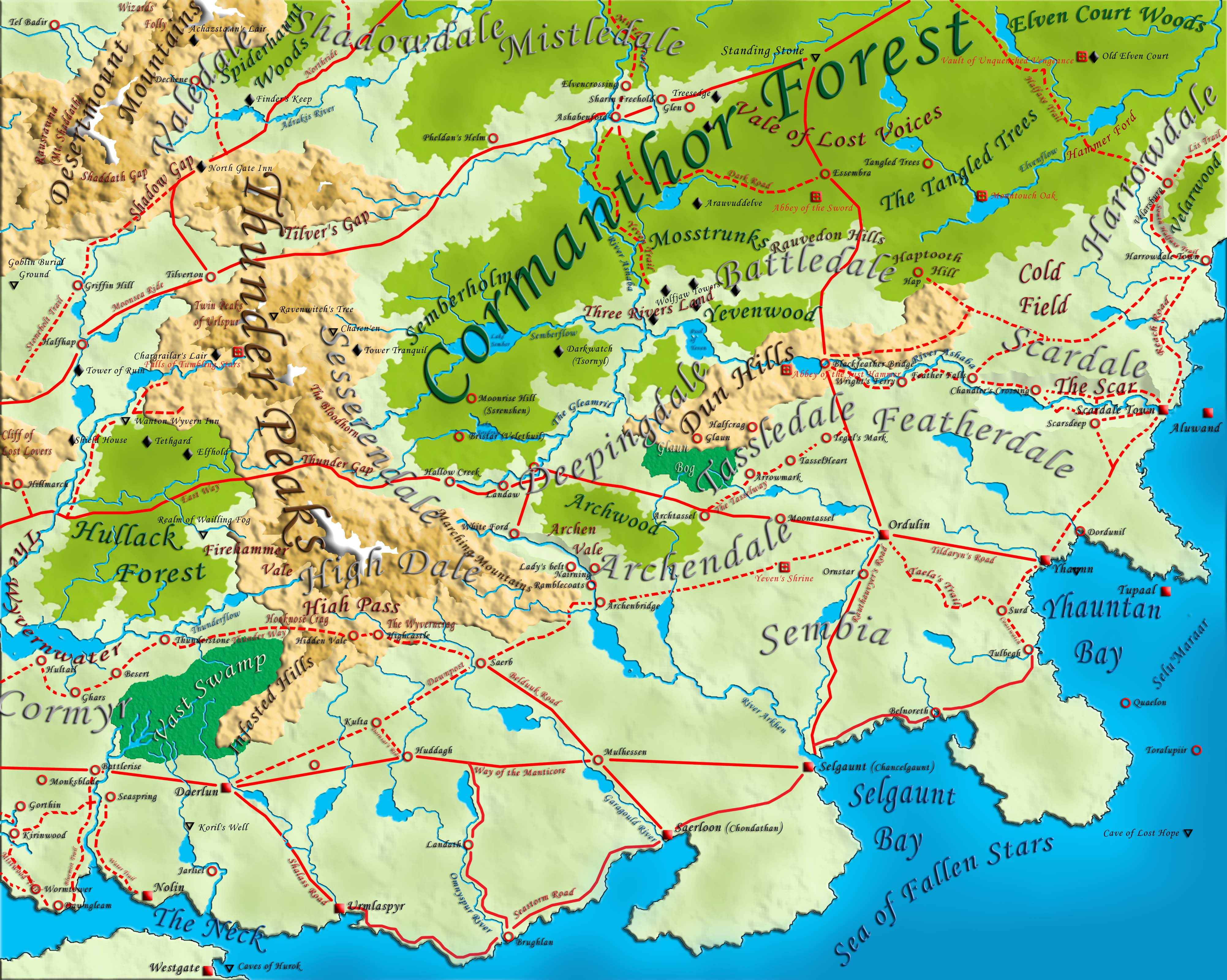
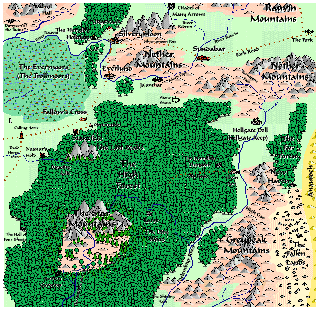
The Dalelands | The Utter East | Archenbridge (Missing from the FRS1 Dalelands product) |
|
|
|
|
|
 |
| Essembra (Missing from the FRS1 Dalelands product) |
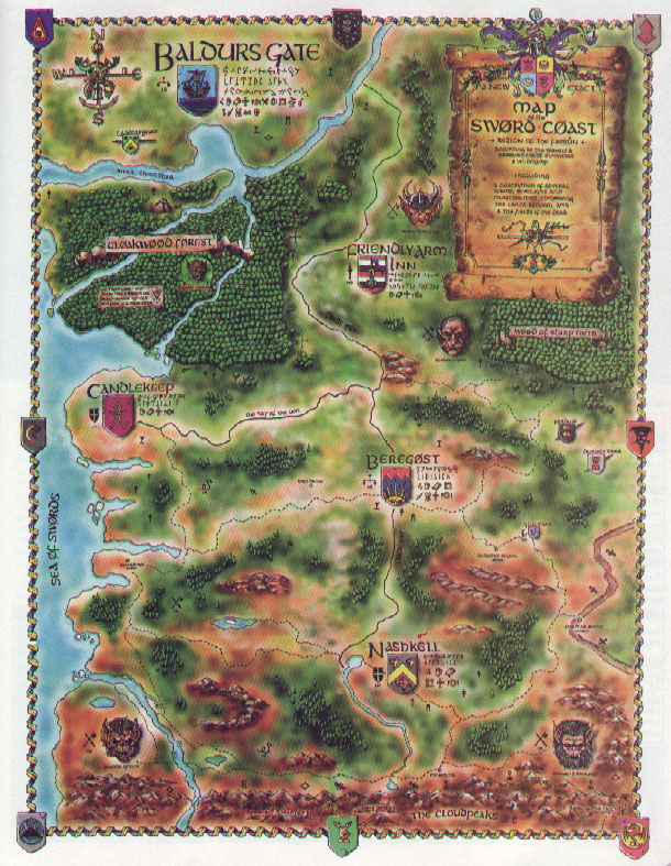
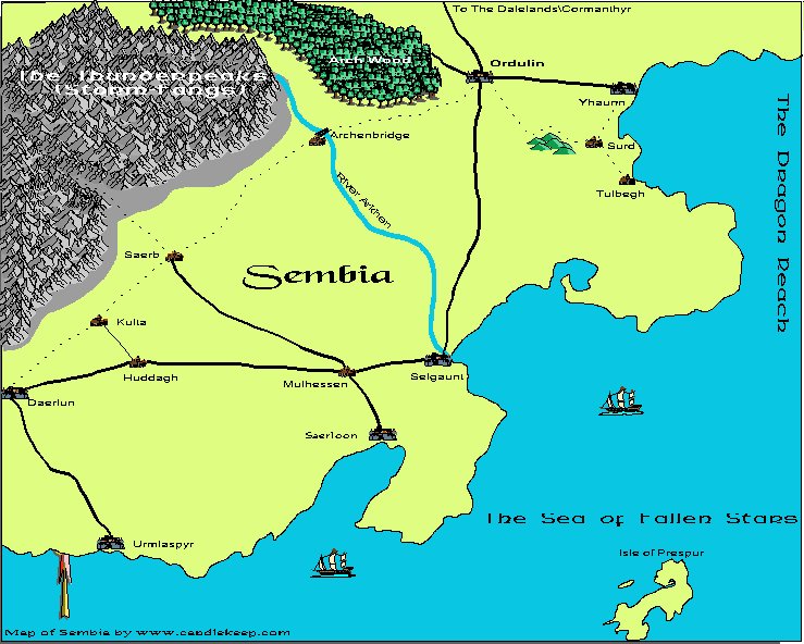
Baldur's Gate map of the Sword Coast | A rough map of Sembia | The Town of Kheldell by Cthulu Ftaghn |
The Dalelands by Patrakis |
 |
 |
 |
 |
 |
Map for "The Twisted Run" - (Dungeon Magazine 129) |
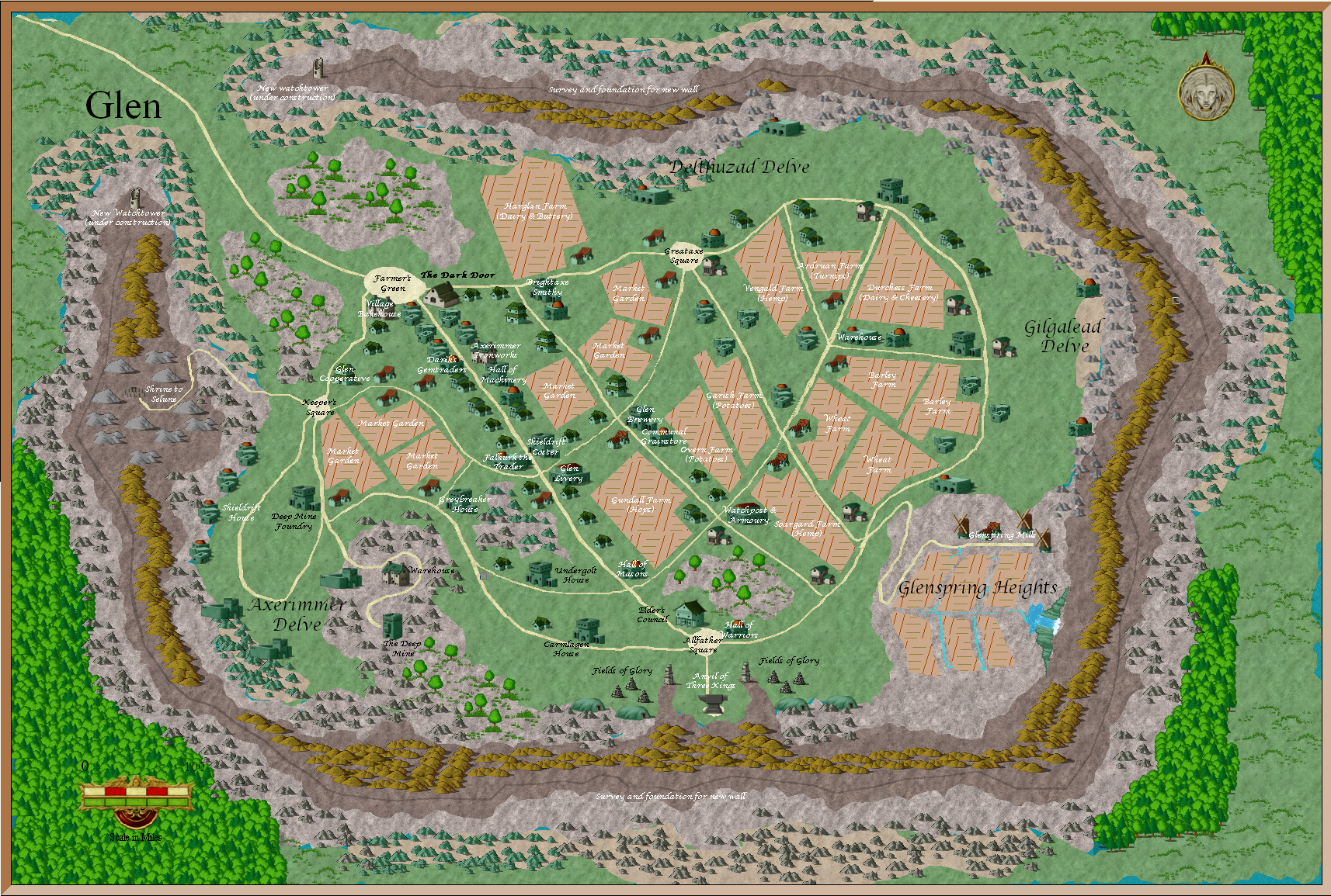
Map of Glen (by Derek Hibberd) |
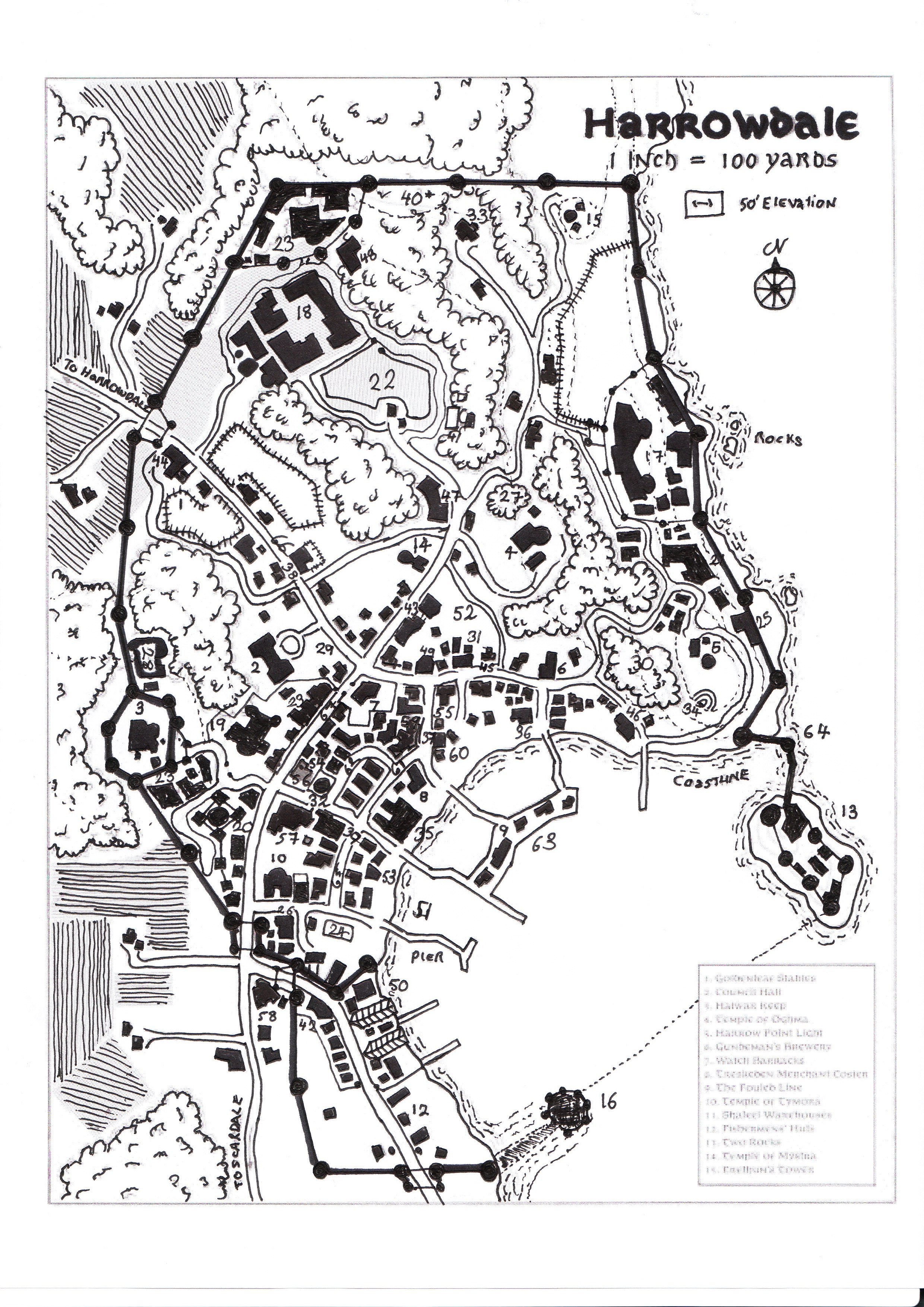
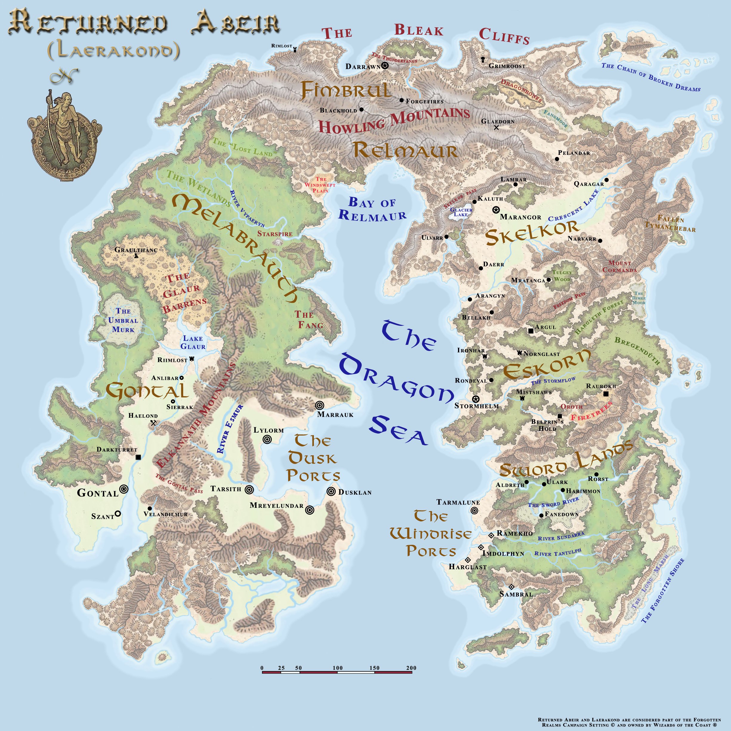
Harrowdale | Laerakond (Returned Abeir) |
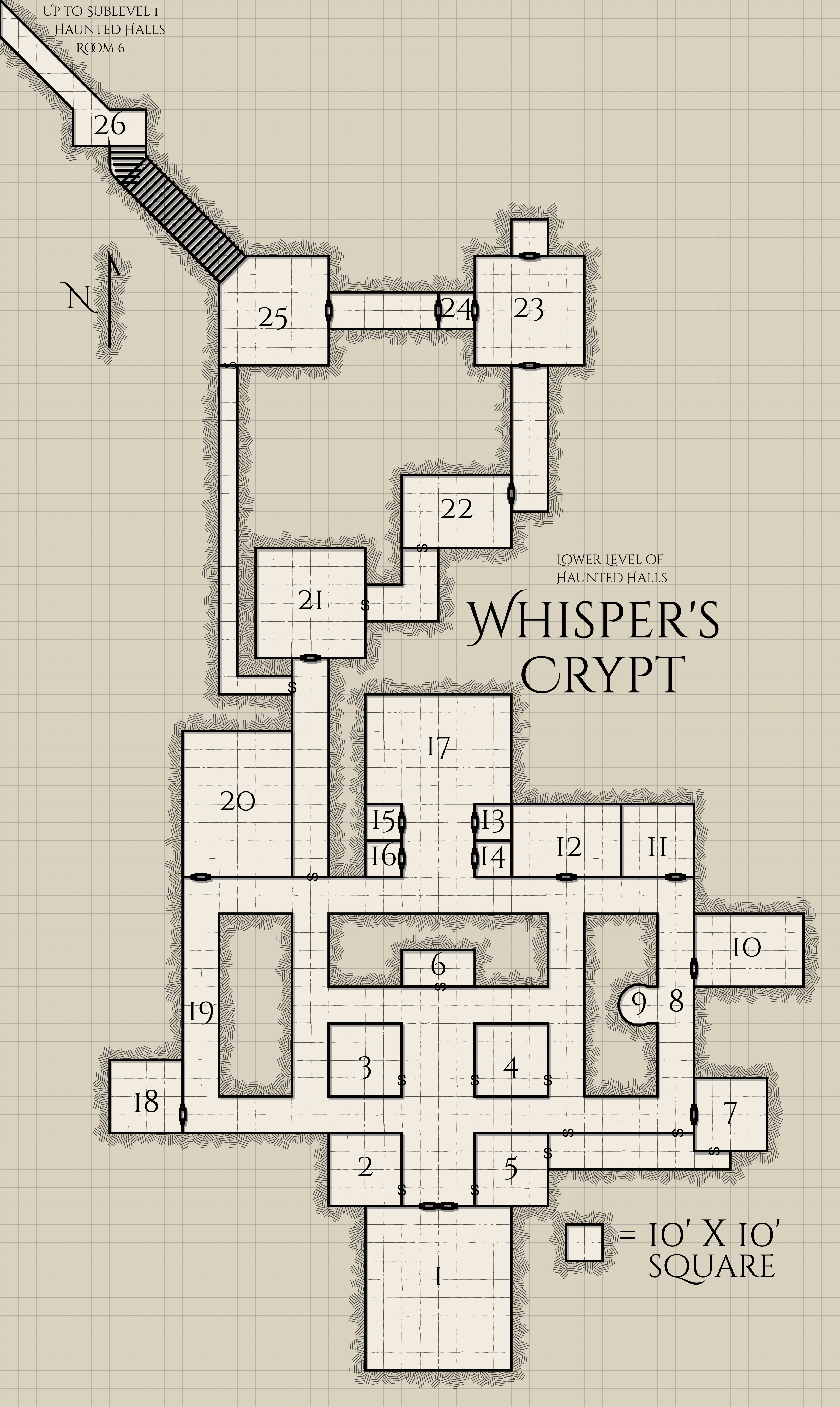
Whisper's Crypt (by Ed Greenwood) |
The following maps are copyright Yack Tundra and are used here with permission by Candlekeep. Candlekeep claims no right to ownership of this material .
 |
 |
 |
Calimshan |
Cormyr |
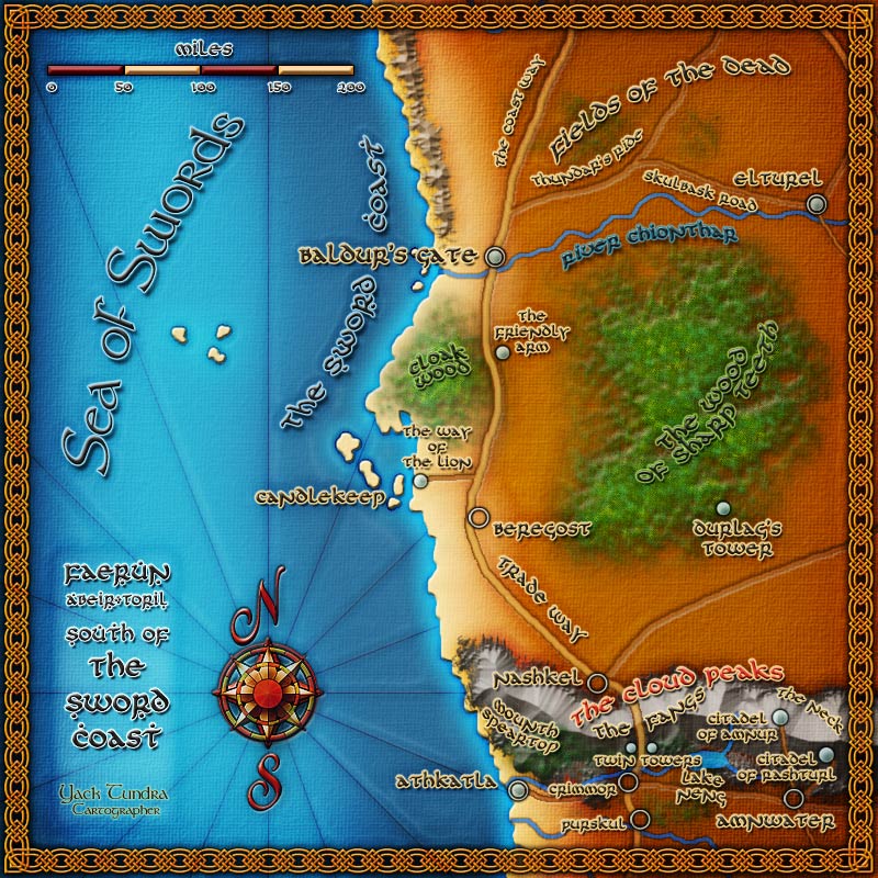
Sword Coast South |
 |
 |
 |
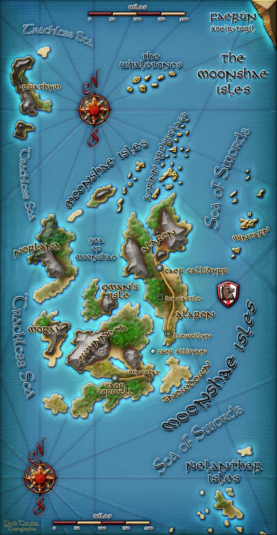
Moonshae Isles |
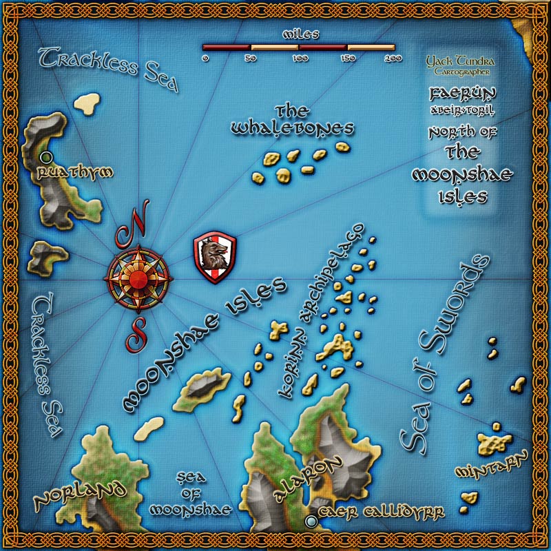
Moonshae North |
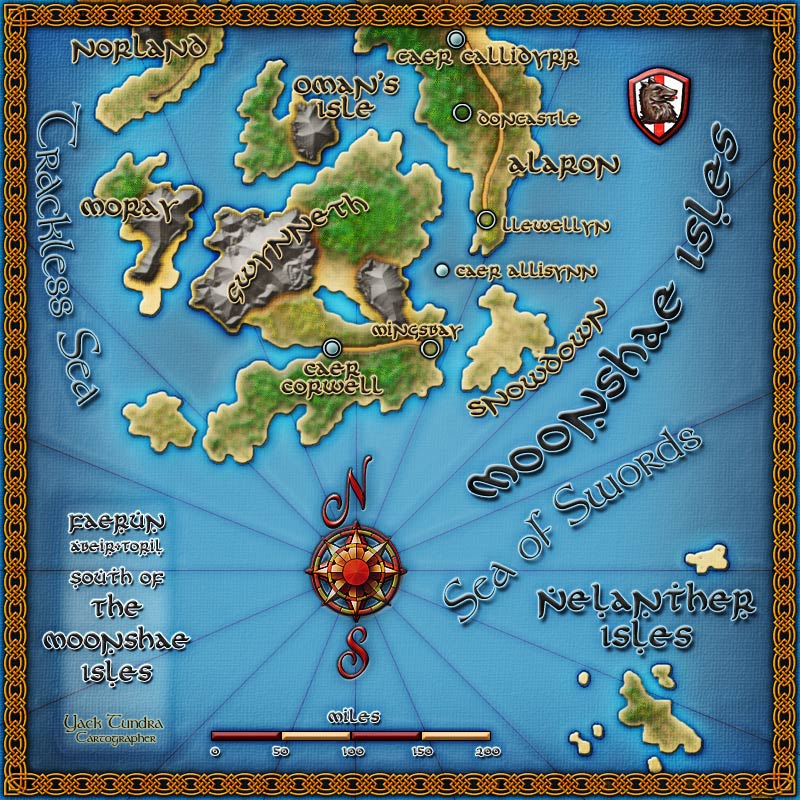
Moonshae South |
 |
 |
 |
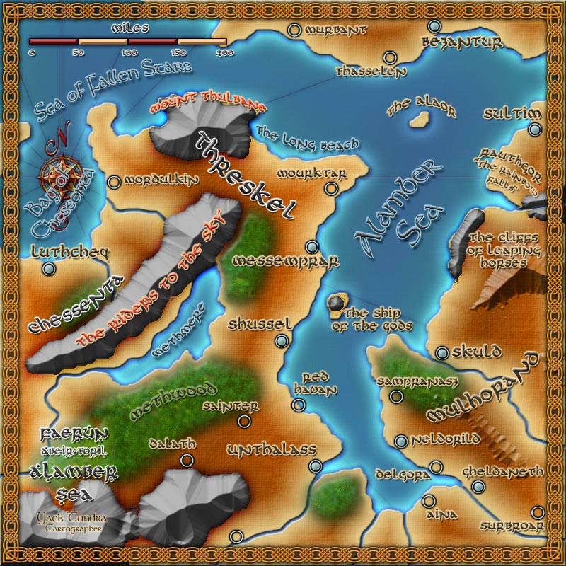
The Alambar Sea |
The Black Jungles |
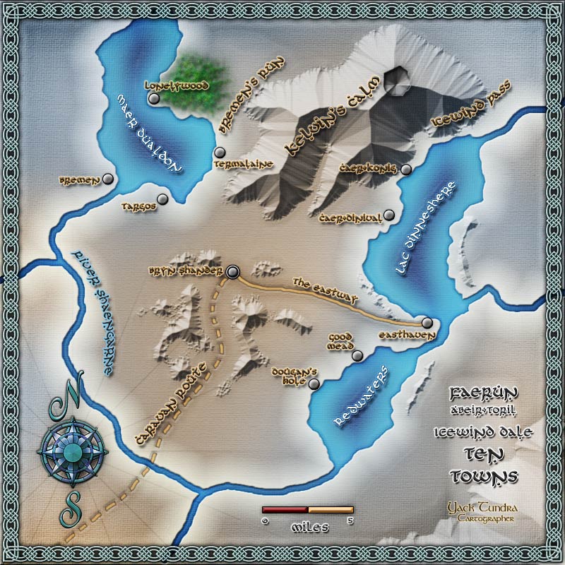
Ten Towns |
Maps by Arravis
The following maps are copyright Arravis and are used here with permission by Candlekeep. Candlekeep claims no right to ownership of this material.
 |
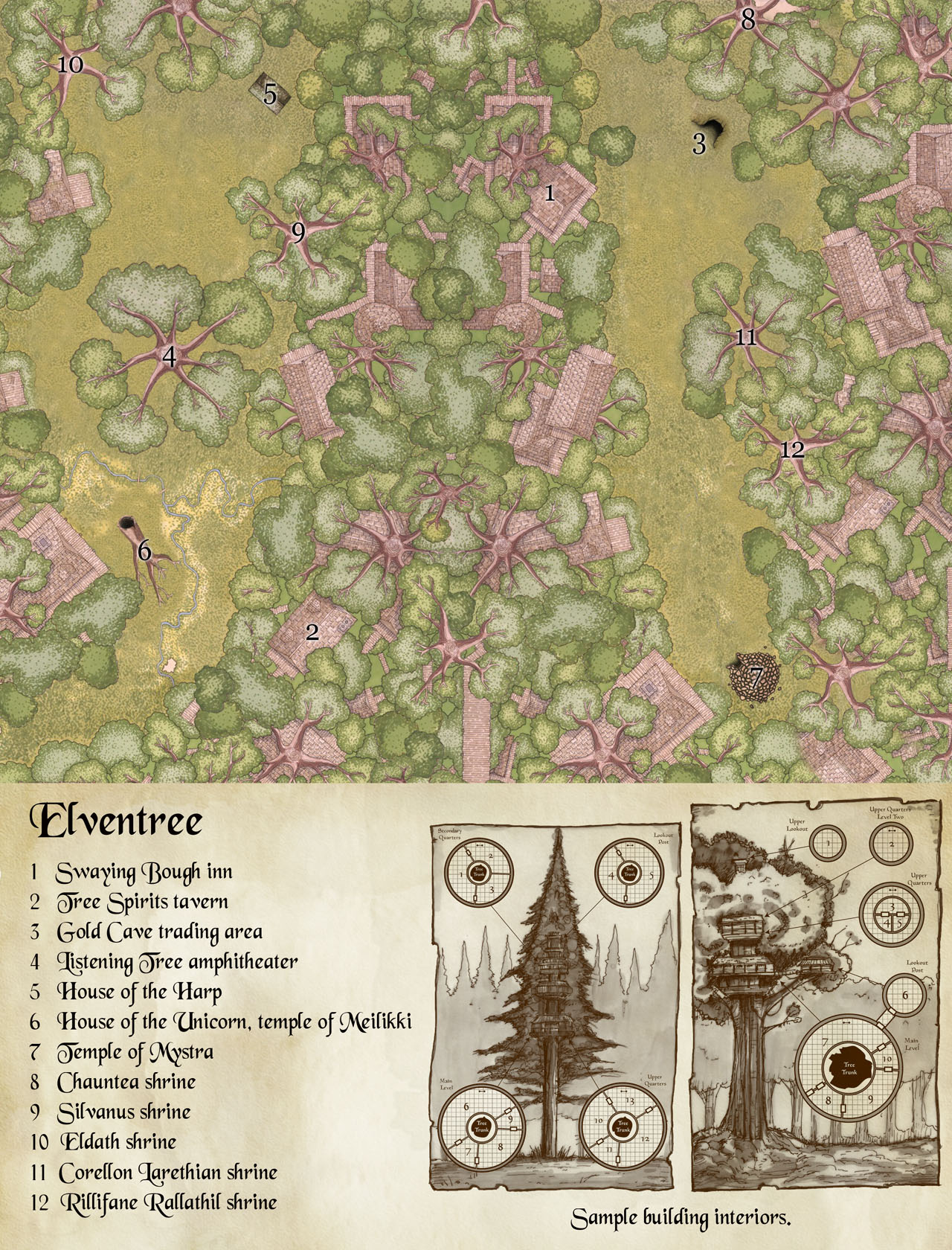 |
Elventree |
|
 |
 |
Phlan |
Essembra |
The following maps are copyright Brian Schutte (a.k.a Mystery_Man) and are used here with permission by Candlekeep. Candlekeep claims no right to ownership of this material.
 |
 |
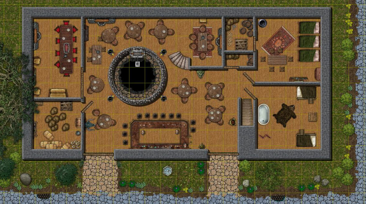
The Yawning Portal (Ground Floor)
|
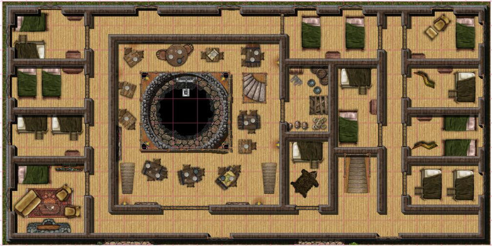
The Yawning Portal (First Floor) |
The following maps are copyright James Bluff (a.k.a BlackAce) and are used here with permission by Candlekeep. Candlekeep claims no right to ownership of this material.
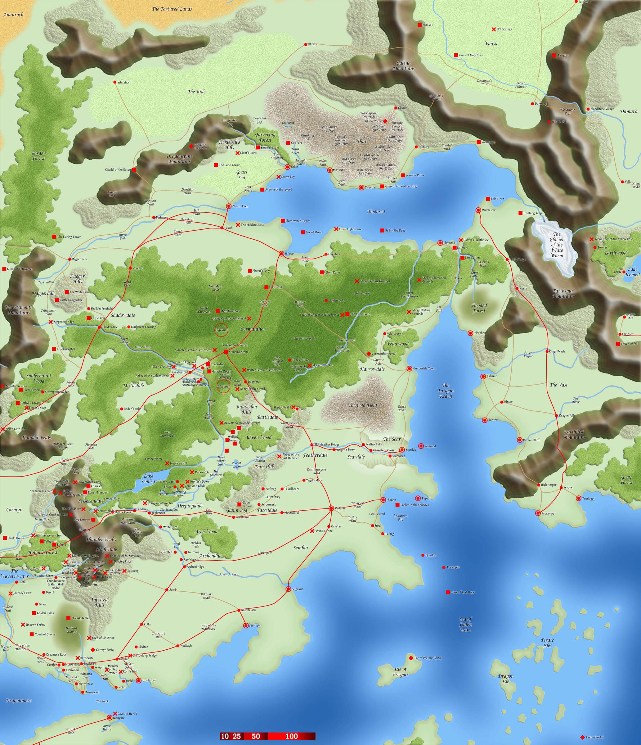
Four part map of Northwest Faerun
"I've tried to stick as closely as I can to, largely 2ed geography (even the stuff from the Battle of Turnstone Pass is in there!) but of course certain compromises have been made where maps have disagreed with each other. The scale was notoriously varied in 3ed Maps...
Generally however, the maps are at their best as handy, quick references for locations in or near were you're planning for your campaign to take place.
Hope you all find them useful"
|
North Part 2 (Upper Delimbyir and Silver Marches) |
 |
 |
North Part 3 (The Moonshae Isles) |
North Part 4 (Western Heartlands) |
The following maps are copyright Mark Taylor (a.k.a Markustay) and are used here with permission by Candlekeep. Candlekeep claims no right to ownership of this material.
|
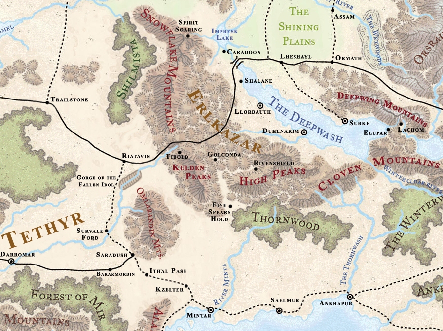
Erlkazar |
This is part 1 of the Map I did for the Silver marches accessory from WotC and the Forgotten Realms campaign setting. I took the world map they have for FREE download on their site, and 'cut' the section out that I needed. I added many locales from both that sourcebook, and the 'North' accessory. This is the four-part map that for DMs, so the scale is qudruple that of the smaller 'handout' map. |
I did this map to compliment The Wailing Dwarf article recently appearing over at WotC. I've greatly expanded the territory covered so as to include the stuff on the Old Valishar Map. A couple of things - The town of Elastam in Erlkazar was created by me, but the Duchy of Elestam was the name of this region when Tethyr controlled it, and there is also a local canon group called "Elestam's Crusaders". It was probably supposed to be a person's name, but I hate leaving crossroads without settlements so I found the closest thing I could to a canon one. The second thing is Redwater Lake; the name is mine, because I consulted at least a dozen sources with the lake, but none of them named it. On my original I called it the "East Lake of the Snake", but that was a mouthful. I took the name from the canon village sitting on it's shores. Everything else should be much closer to the original 2e maps then my last one, and I included many new locales I found. Some things may appear a little off from their 2e locations, but this area was greatly reduced so some ‘squishing’ was required to fit everything back in. When a discrepancy occurred between maps, I always deferred to text sources for exact placement. If you're not familiar with my map Symbols (they are slightly different then the official ones), refer to the Map Key also on my site. One major difference is the Octagon with the ‘X’ in the middle – it denotes an abandoned site, rather then a ruin. |
 |
 |
The Hordelands |
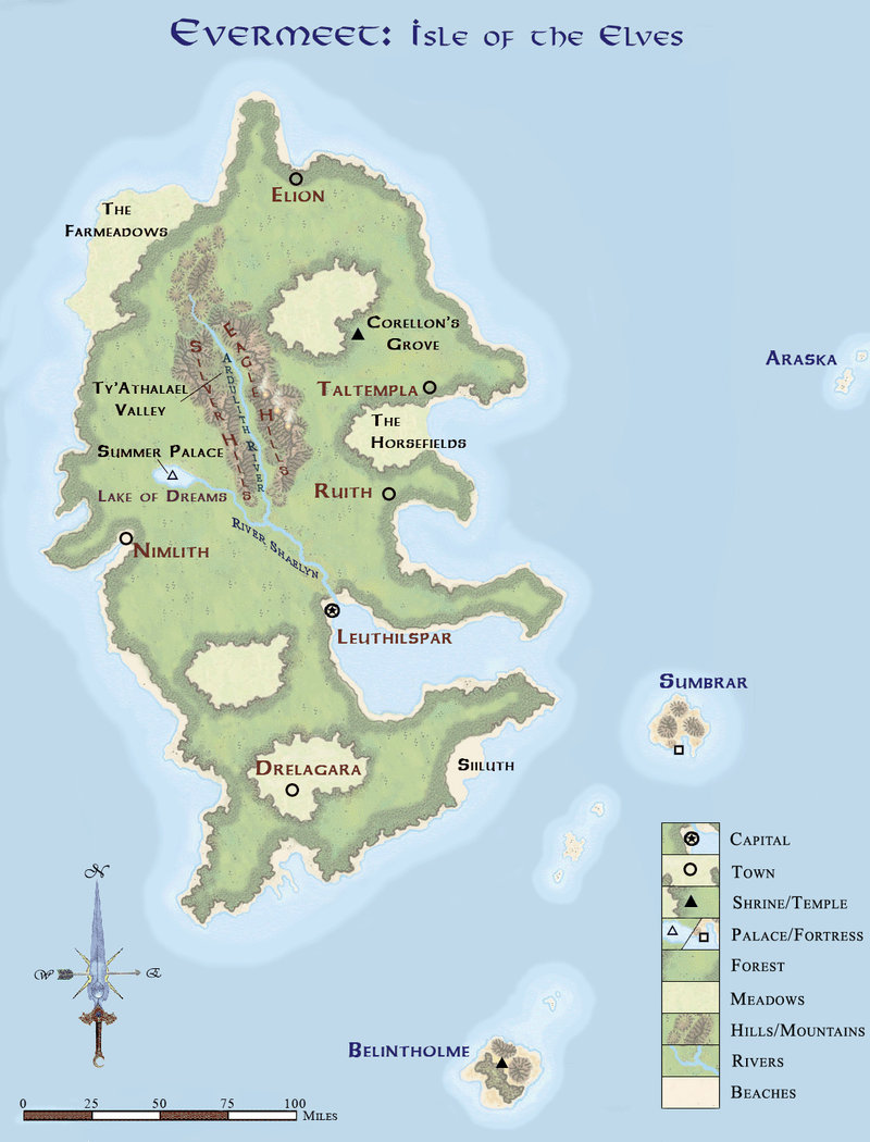
Evermeet |
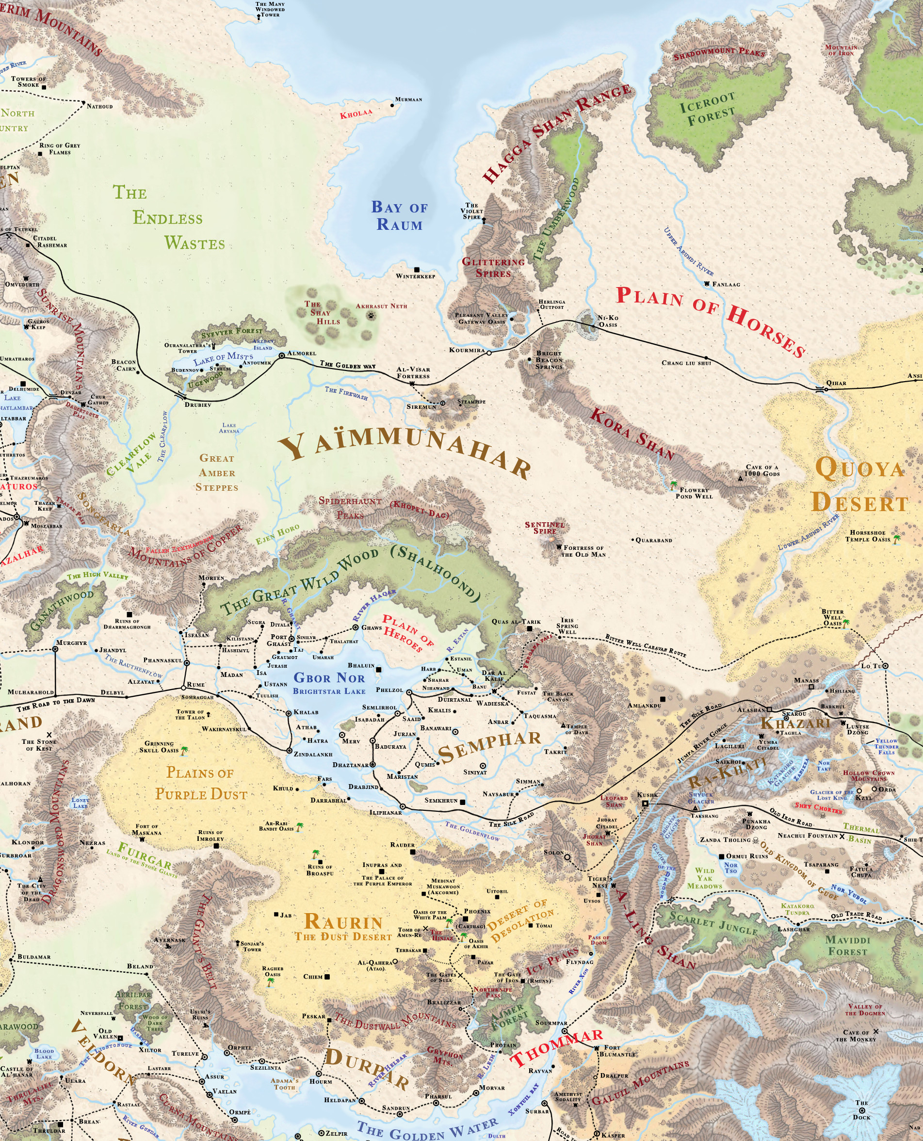
Finally got this part finished. It's 95% canon from the old 2e Horde Maps, along with stuff added from modules. The rolling hills above Ejen Horo was my idea, because the Copper Mountains moved further away with 3e, and I wanted a way of defining that special area from the upper regions. Also, the name "Clearflow Vale" was my add, to help keep track of the different parts of the waste. The same goes for the "Dry Steppes". As usually, I tried to get everything back where it belong by modifying the 3e maps to conform to 2e lore. The biggest problem was the region between the Godswatch Mountains and the Jumpa river gorge - after rotating the map back to its original angle the lower half of the Hordelands got 'squished' (and the Horse Plains gained some room). I did the best I could, but Jorhat Citadel wound up north of Leopard Shan, when it should have been south. I suppose I could have shrunk Semphar up a bit, but I did that country awhile back, and only added the four campaign maps together recently. I didn't want to have to re-do Semphar from scratch, and the region that got compressed wasn't very important anyway. This region goes north of my 'Golden Waters/Ulgarth' map already posted. EDIT: This NEWEST version has TWO non-canon locations - the Al-Visar Fortress and the Ruins of Troos. The fortress is the northeastern outpost of of the new nation of Yaimmunahar, constructed of Purple Stone salvaged from the Raurin Desert (and it radiates a slight magical aura). The ruins of of the capitol of lost Tsharoon, a short-lived kingdom that was swallowed up by the Quoya desert some 800 years ago. |
|
 |
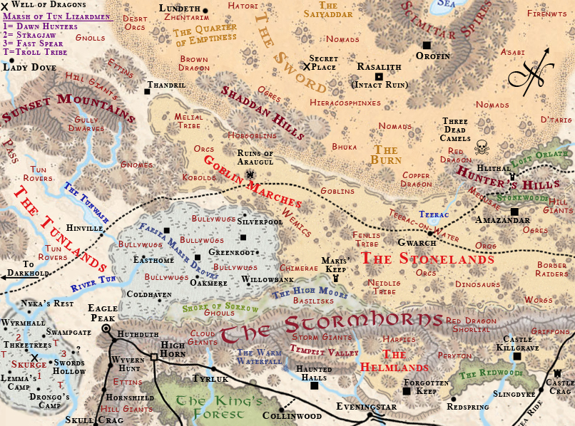 |
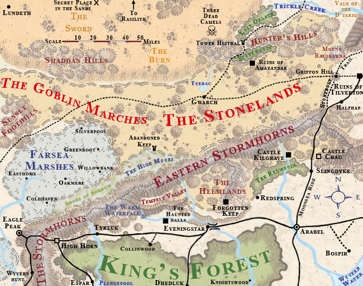
The Stonelands |
The Stonelands (DM's map) |
Mostly canon, except for a couple things I added, like the small forests and the town of Collinwood. Gwarch is a creation of my own, and is based on canon tidbits - the Teerac-on-water goblins are smarter and more civilized then most, and they live FAR longer (100 years!). They are also noted for wearing chainmail, and trading with the locals (including humans). Since the route across the desert is now blocked by Shade, I figure these goblins have set up a little 'Trading-post' operation here. The site has grown into a small village of it's own, and the enterprising little buggers are doing quite well. New Zhentish trail - Not canon, just conjecture on my part. Most maps leave that small clear area blank except fot the river. The D'tarig are canon and are said to be decendents of the Mines of Tethyamer, which the Hlundadim goblins attacked and took over centuries ago. |
This is the DM's map for running a Stonelands campaign, and comes with all of the stuff players shouldn't know, like Monster locations. The locations were taken from the various Elminster's Ecologies Sourcebooks that apply to this region (there are 3, maybe 4, counting the Battle of the Bones). I have aadded in a couple of monsters of my own, but not that many (like the Ghouls and Desert Orcs), just to round out the selection and help out the DM. The Marsh of Tun turned out to be a VERY busy place, hence the 'map Key' in the corner. Skurge is the name of the Black Dragon that lives there. Hinville is another creation of mine, based on both the nearby Darkhold and Halfling settlements. This is where the 'bad' halflings go... the ones your mother warned you about. Its a ruf-and-tumble frontier town of mostly halflings, several of which are Zhentarim agents.
|
 |
 |
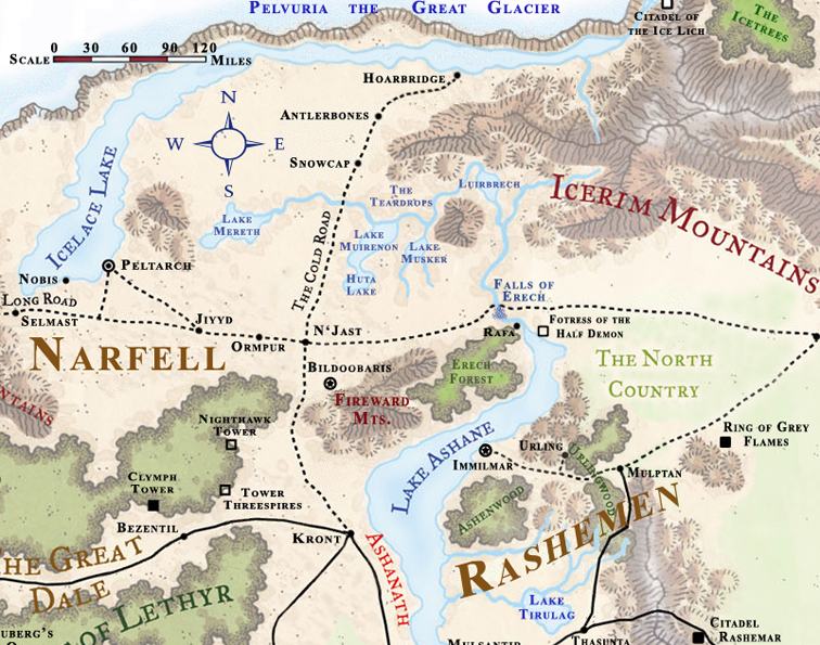
The North East |
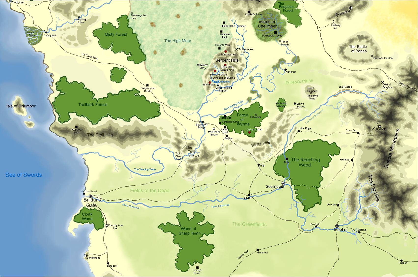
Veldorn |
This was a quicky I did for someone. The town of Rafa was for his campaign, and the Citadel of the Ice Lich was my add. Everything else should be canon. |
Map of the Monster Kingdom Veldorn. There a quite a few other towns in Veldorn, each control by a different type of monster. Only the towns shown are named in text, however. Modified and updated on 8/30/07. The towm of "Brea" was my add is NOT canon (it just seemed funny with all of those roads nearby, and no town. I figure this city sprung-up since the Evil Druid took over Thruldar, and the roads shifted slightly east to accomodate it. |
 |
 |
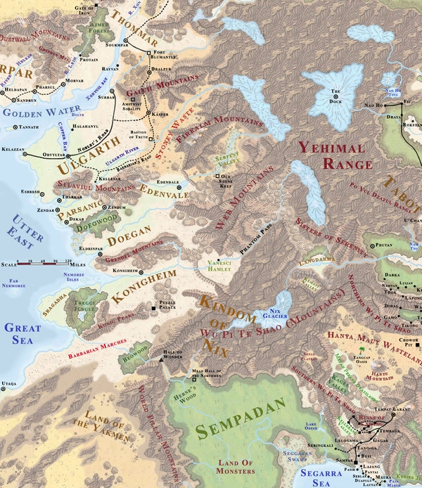
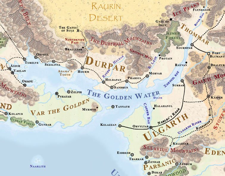
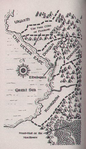
Utter East |
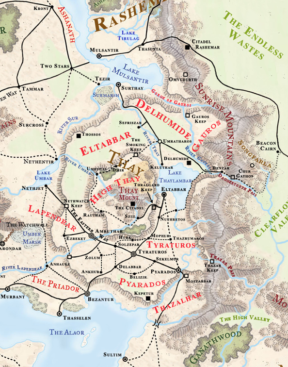
Thay and environs |
Version 7 I changed the name of the nearby forest, because I borrowed the first one from WH Campaign. The new name better reflects the beings that live deep in the dark and forbidding jungle - the TROW!!! Half-troll, half-drow; this horrific race has been troubling the Loxo and and Konigheim for centuries. If you want to know what they look like, see various fanart of the blue-skinned trolls from WoW. |
This is MY Thay. All locations are canon - I have made some minor changes to geography to have things fit better with older maps. All the roads are canon as well, except for the 'dotted line' leading from the mountains to beacon Cairn. It just seemed kind of strange to me for the trail to just end at the mountains, so I made a path to where I think the Thayans would be most interested in going. A black dot is a settlement, a circle a small city, a circle with a dot a large city, and two circles with a dot (the bullseye looking thing) is a metropolis. The circle with the square in it (Glarondar) is a fortified city. All other map symbols conform to the official FR maps. |
 |
|
The Shining Lands |
Impiltur |
Just a small preveiw of a tiny piece of my continental map, showing the area where the four campaign settings come together (FR, Horde, KT, and AQ). Just so everyone knows, I added two locations to this map for my own campaign. The small coastal city San Tuar is actually Sanctuary, the city from the Thieves World novels (I have some old 1e maps for it). All I did was omit the the "c" and "y". It's a pirate haven for Corsairs coming up from the south (and their islands are actually just off the southern edge of the map). The king of Ulgarth is well aware of the towns existance, but thanks to some deals that were made with the Corsairs during the Tuigen wars the king turns a 'blind eye' to the town. I also added the small 'village' of Maiz, which is only occupied for a few months out of the year during the trading season. Minotaurs who dwell up in the HUGE mountain range come down and trade with merchants from Ulgarth here; they are much more civilized then minotaurs found elsewhere, and are shorter with human feet rather then hooves (think Krynn Minotaurs). All of that is my own concoction, so your free to ignore it. The rest of the map is 100% canon from 1e, 2e, and 3e sources, with a tiny bit of poetic license thrown in for 'artistic value'. Looking back, I realize their may be some confusion for folks looking at the 2e Shining South maps of Ulgarth. The rivers you see did NOT appear on THAT map, nor on ANY other Faerun map, yet I can still honestly say they are canon. If you also use the Kar-Tur trail map and piece it into the continent of Faerun, all of the natural geography of Ulgarth is shown in the 'neck' of land connecting Zakhara, and therein lies the rivers. That map didn't have any of the man-made details, so my map is a combination of ALL existing maps, not just FR. I think I may have also named the river though, but the road names are all canon. |
. |
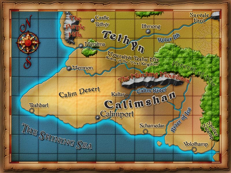
Calimshan |
Halruaa |
All locations are canon, and as close to their original 2e positions as possible. Several locales were adjusted slightly from the original do to corrections when referncing the text sources. The desert was stretched a bit to better fit everything, and give more of feeling of endless wastes. Some Hills were added to the Northeast corner of the Forest of Mir to better place Argentor and Uller's Hill, and also allows the name of the town 'Ithal Pass' to make more sense on the 3e map. Volothamp is correctly placed, and is supposed to exist at the top of a series of plateaus, into which the city dwellers have dug extensive mines. |
I tried to place all of the 2e cities and towns as best I could given the changes to Halruaa's shape between editions. There was an 'unamed town' just above Talathgard on the original map, that I wanted to include. The first problem was the location - the Bandit Pass was no longer next to Mount Tallath - things had shifted quite a bit. I decided it should be a Large Fortress (Citadel), reflecting the proximity to the Bandit Wastes, so I kept it closer to it's original site, moving it further away from Talathgard, which it used to be NW of. I like that it's on the end of the Bandit Pass, and of course I changed it from a Town to a Fortress (the size of town, with many civilians living within the walls in 'support roles'. It is named after Halruaa's founder. I also 'coolified' the area around Mhairhetol - When I rotated the maps back to their original, and merge the official halruaa with the rotated one, things got a little weird in that corner (I wound up with duplicate mountains), especially since I 'smushed' stuff to get Sharreach back. I think it looks much better now (Volcanos!), and that narrow strip of Jungle is a nice little addition for DMs to develop as they see fit. The map in the 3e SS book showed a little 'booger' of land sticking out in the SW, that doesn't show up on any other map. The old 2e SS map shows an island there - so I compromised. The land is now a Bayou-like Jungle-filled swamp that can actually be crossed over in quite a few places in shallow boats, and becomes disconeccted from the mainland during storms or other periods of exceptionally high tides. I also made up the name. Everything Else should be canon, although I did take the liberty of putting 'swampy' terrain in the Azhal pass (it seemed appropriate). I'm thinking 4e Swamp-halflings in Zhal. |
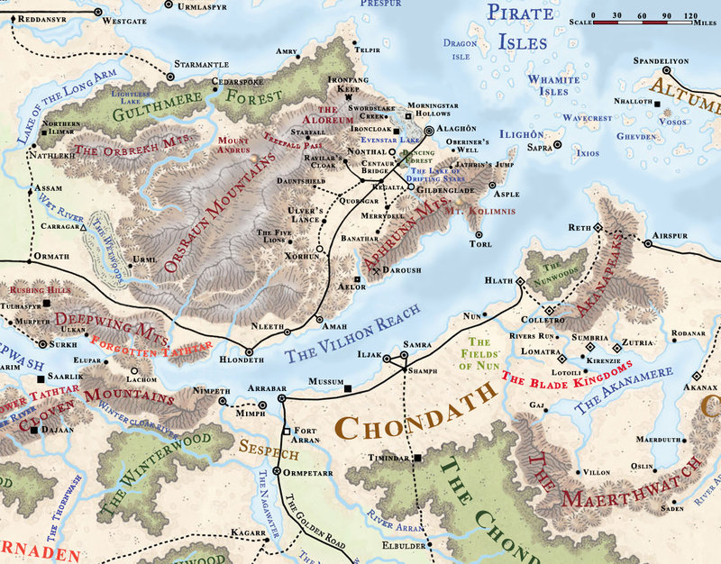
The Vilhon Reach |
|
The Vilhon Reach - all locations are canon. Some things have been moved around a little to accomodate the 3e map (Turmish shrunk since 2e). Also, the bog in Turmish between Morningstar Hollows and Ironcloak is canon (from text), but was never named. It was said to be expanding in 2e, so I figure this is what it looks like in 3e/4e. If you need a name for it, just call it Evenstar Bog (after the lake). There are also two time portals located in the Orsraun Mts that I didn't bother to include - one under the volcano.
Keep in mind this is my version of the FR maps, and I have grealy reduced the Sea of Falling Stars and re-arranged the islands in my game, so everything wil be closer together. Strangely enough, the new size of the SoFS works better for a 4e map. |
The following maps are copyright Elliott Zastrow and are used here with permission by Candlekeep. Candlekeep claims no right to ownership of this material.
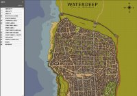
Waterdeep |
|
Note that this is a 5.6MB ZIP\PDF download This is map of the city of Waterdeep in Adobe PDF format (Adobe Acrobat Reader required to view). It includes all structures, landscape, roads and the sewer system. Most buildings detailed in 2e and 3e Forgotten Realms products are present, with labels and short descriptions. The map is 1:3048 scale and viewable on a 0 to 6400% zoom level (small enough to show 5'x5' grid squares). Please be aware that this is a HUGE map, and may be difficult to view on systems with less than 512MB of RAM. Also this file may cause MacOS X systems to hang due to a bug in OS X's file preview function (Windows/Linux/Unix are fine). Please direct any comments, suggestions, or errata notices to the author (ehzastrow AT gmail DOT com). |
The following maps are copyright Corentin Palanchini and are used here with permission by Candlekeep. Candlekeep claims no right to ownership of this material.
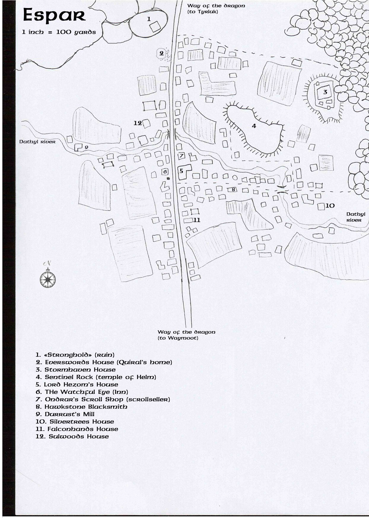
Espar (Cormyr) |
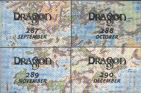
Maps from Dragon Magazine
Between September and December 2001, Dragon Magazine produced a large poster map of Faerun, so large that it is released in four parts spread over four issues of Dragon (Issues 287-290). The image below shows how the poster maps were divided up and over which issues of the magazine they are included:
Due to the release of the Interactive Forgotten Realms Atlas by TSR, only Campaign Mapper maps created by the fans will appear in this section (with the exception of the first item, "The Sword Coast" or others made available for free distribution by permission of TSR) to avoid possible copyright violations to sales of the actual product.
|
|
|
|
|
|
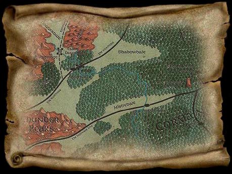
Evermoor |
Visit the Profantasy website for other Campaign Mapper catalogs and maps.


